
Gracias por apoyar a este sitio ❤️
Haz una donación
Haz una donación
Mapa topográfico Clear Creek
Haga clic en el mapa para ver la altitud.
Gracias por apoyar a este sitio ❤️
Haz una donación
Haz una donación
Acerca de este mapa
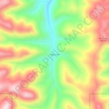
Nombre: Mapa topográfico Clear Creek, altitud, relieve.
Lugar: Clear Creek, Carbon County, Utah, United States (39.62580 -111.17239 39.66580 -111.13239)
Altitud media: 2.726 m
Altitud mínima: 2.466 m
Altitud máxima: 2.978 m
Gracias por apoyar a este sitio ❤️
Haz una donación
Haz una donación
Otros mapas topográficos
Haga clic en un mapa para ver su topografía, su altitud y su relieve.
Scofield Reservoir
United States > Utah > Carbon County
Scofield Reservoir is a 2,815-acre (11.39 km2) reservoir impounded by Scofield Dam, in Carbon County, Utah. Located on the Price River, a tributary of the Green River, Scofield Reservoir is adjacent to northernmost boundary of the Manti–La Sal National Forest. The reservoir sits at an elevation of 7,618 feet…
Altitud media: 2.435 m