
Gracias por apoyar a este sitio ❤️
Haz una donación
Haz una donación
Mapa topográfico Shahimardan
Haga clic en el mapa para ver la altitud.
Gracias por apoyar a este sitio ❤️
Haz una donación
Haz una donación
Shahimardan
Shakhimardan City Resort is situated at 1975m above sea level, 155 km from Ferghana, in the picturesque mountainous district. The Kuliqurbon or Blue Lake is seven kilometers southeast of Shakhimardan. It was formed in 1766 after a series of extreme earthquakes. The lake is located at an altitude of 1,724 metres. It's 170 m long, 60 m tall, 5–10 m deep. The cableway continues to the lake for two kilometres.
Gracias por apoyar a este sitio ❤️
Haz una donación
Haz una donación
Acerca de este mapa
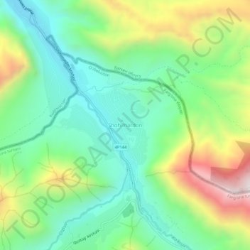
Nombre: Mapa topográfico Shahimardan, altitud, relieve.
Altitud media: 1.609 m
Altitud mínima: 1.306 m
Altitud máxima: 2.204 m
Gracias por apoyar a este sitio ❤️
Haz una donación
Haz una donación