
Gracias por apoyar a este sitio ❤️
Haz una donación
Haz una donación
Mapa topográfico Tatry
Haga clic en el mapa para ver la altitud.
Gracias por apoyar a este sitio ❤️
Haz una donación
Haz una donación
Tatry
The Tatras lie in the temperate zone of Central Europe. They are an important barrier to the movements of air masses. Their mountainous topography causes one of the most diverse climates in that region.
Gracias por apoyar a este sitio ❤️
Haz una donación
Haz una donación
Acerca de este mapa
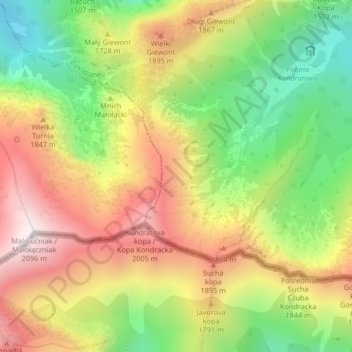
Nombre: Mapa topográfico Tatry, altitud, relieve.
Altitud media: 1.647 m
Altitud mínima: 1.226 m
Altitud máxima: 2.084 m
Gracias por apoyar a este sitio ❤️
Haz una donación
Haz una donación
Otros mapas topográficos
Haga clic en un mapa para ver su topografía, su altitud y su relieve.
Czarny Staw Gąsienicowy
Poland > Lesser Poland Voivodeship > Tatra County > Zakopane
Altitud media: 1.799 m