
Haz una donación
Mapa topográfico Fifteenth Of May
Haga clic en el mapa para ver la altitud.
Haz una donación
Acerca de este mapa
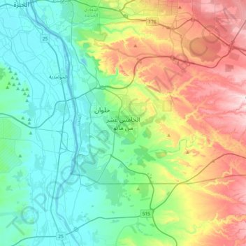
Nombre: Mapa topográfico Fifteenth Of May, altitud, relieve.
Lugar: Fifteenth Of May, Cairo, 11748, Egypt (29.67204 31.20477 29.99204 31.52477)
Altitud media: 151 m
Altitud mínima: 12 m
Altitud máxima: 467 m
Haz una donación
Otros mapas topográficos
Haga clic en un mapa para ver su topografía, su altitud y su relieve.
New Cairo City
Located in what was formerly Helwan Governorate, and located to the east of Maadi and Heliopolis, New Cairo ranges in elevation between 250 and 307 metres (820 and 1,007 ft) above sea level.
Altitud media: 227 m
New Cairo City
New Cairo is built in the Eastern Desert to the east of the Cairo Ring Road and the modern 1950s extension of Nasr City, on a plateau that ranges in elevation between 250 and 307 metres (820 and 1,007 ft) above sea level. It was created to comprise three towns (The First, Third, and Fifth settlements),…
Altitud media: 227 m
Haz una donación
Haz una donación
Haz una donación
New Cairo City
New Cairo is built in the Eastern Desert to the east of the Cairo Ring Road and the modern 1950s extension of Nasr City, on a plateau that ranges in elevation between 250 and 307 metres (820 and 1,007 ft) above sea level.
Altitud media: 227 m
Haz una donación
New Cairo City
New Cairo is built in the Eastern Desert to the east of the Cairo Ring Road and the modern 1950s extension of Nasr City, on a plateau that ranges in elevation between 250 and 307 metres (820 and 1,007 ft) above sea level.
Altitud media: 227 m
Haz una donación
Haz una donación
Haz una donación
Al Azhar Park
In 1984, Aga Khan IV was visiting Cairo on a conference. From his hotel balcony; Al-Darassa hill (Arabic: هضبة الدراسة) was visible: mounts of wreckage and ruins amassed during 500 years. He decided to intervene and offer that medieval area via the Historic Cities Support Programme the…
Altitud media: 53 m
Haz una donación
Haz una donación
Al Azhar Park
In 1984, Aga Khan IV was visiting Cairo on a conference. From his hotel balcony; Al-Darassa hill (Arabic: هضبة الدراسة) was visible: mounts of wreckage and ruins amassed during 500 years. He decided to intervene and offer that medieval area via the Historic Cities Support Programme the much-needed…
Altitud media: 53 m
Haz una donación