
Haz una donación
Mapa topográfico Bocaue
Haga clic en el mapa para ver la altitud.
Haz una donación
Acerca de este mapa
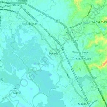
Nombre: Mapa topográfico Bocaue, altitud, relieve.
Lugar: Bocaue, Bulacan, Central Luzon, 3018, Philippines (14.75964 120.88646 14.83964 120.96646)
Altitud media: 7 m
Altitud mínima: -2 m
Altitud máxima: 35 m
Haz una donación
Otros mapas topográficos
Haga clic en un mapa para ver su topografía, su altitud y su relieve.
Pulilan
The municipality is generally of flat topography. Eleven (11) of its barangays are bounded by the Angat River. The rest are flat irrigated rice lands. Soil types vary from sandy loam to clay loam which makes the municipality suitable to a wide range of agricultural products.
Altitud media: 10 m
Haz una donación
Obando
Flat and low-lying coastal plains characterize the general topography of Obando. The area was formerly an estuary, but it filled up partially from the peripheral parts of each sand bar and sand spit and formed up into current figure that mainly consisted of commercial district, partly industrial district,…
Altitud media: 4 m