Geolocalizar

Mapa topográfico Qingxiu

Haga clic en el mapa para ver la altitud.

Acerca de este mapa

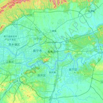
Nombre: Mapa topográfico Qingxiu, altitud, relieve.

Lugar: Qingxiu, Nanning, Guangxi, 530028, China (22.65608 108.25045 22.97608 108.57045)

Altitud media: 113 m

Altitud mínima: 57 m

Altitud máxima: 431 m

Otros mapas topográficos

Haga clic en un mapa para ver su topografía, su altitud y su relieve.

Guilin

China > Guangxi

Guilin (Standard Zhuang: Gveilinz), formerly romanized as Kweilin, is a prefecture-level city in the northeast of China's Guangxi Zhuang Autonomous Region. It is situated on the west bank of the Li River and borders Hunan to the north. Its name means "forest of sweet osmanthus", owing to the large number of…

Altitud media: 472 m

Qingxiu District

China > Guangxi > Nanning

Altitud media: 140 m

Liuzhou City

China > Guangxi

Altitud media: 433 m

Xiufeng District

China > Guangxi

Altitud media: 176 m

Tianyang District

China > Guangxi

Altitud media: 415 m

Long'an County

China > Guangxi > Nanning

Altitud media: 255 m

Bagui

China > Guangxi > Tianlin County

Altitud media: 575 m

Guilin

China > Guangxi

Guilin (Standard Zhuang: Gveilinz), formerly romanized as Kweilin, is a prefecture-level city in the northeast of China's Guangxi Zhuang Autonomous Region. It is situated on the west bank of the Li River and borders Hunan to the north. Its name means "forest of sweet osmanthus", owing to the large number of…

Altitud media: 472 m

Youjiang District

China > Guangxi > Baise

Altitud media: 532 m

Liuzhou City

China > Guangxi

Altitud media: 433 m

Yaru Subdistrict

China > Guangxi

Altitud media: 90 m

Guigang

China > Guangxi

Altitud media: 185 m

Mengshan County

China > Guangxi

Altitud media: 385 m

Liuzhou City

China > Guangxi

Altitud media: 433 m

Bagui

China > Guangxi > Tianlin County

Altitud media: 574 m

Liangqing

China > Guangxi > Nanning

Altitud media: 98 m

Pingnan County

China > Guangxi

Altitud media: 207 m

Yongning District

China > Guangxi > Nanning

Altitud media: 118 m

Mengshan County

China > Guangxi

Altitud media: 385 m

Hezhou

China > Guangxi

Hezhou is located in northeastern Guangxi. It borders Hunan to the north and Guangdong to the east. The area is 11,752.64 km2 (4,537.72 sq mi). The average elevation is 800 m (2,600 ft) and the highest is 1,731 m (5,679 ft) above sea-level.

Altitud media: 393 m

Maowei Sea

China > Guangxi > Qinzhou

Altitud media: 9 m

Pingle County

China > Guangxi > Guilin

Altitud media: 390 m

Ningming County

China > Guangxi

Altitud media: 332 m

Xiangshan District

China > Guangxi > Guilin

Altitud media: 179 m

Baise

China > Guangxi

Baise has a monsoon-influenced, humid subtropical climate (Köppen Cwa), with short, mild, and dry winters, and long, very hot and humid summers. The monthly 24-hour average temperature ranges from 13.5 °C (56.3 °F) in January to 28.4 °C (83.1 °F) in July, for an annual mean of 22.12 °C (71.8 °F).…

Altitud media: 688 m

Liuzhou City

China > Guangxi

Altitud media: 433 m

Li River

China > Guangxi > Luchuan County > Dashan

Altitud media: 83 m

Tianping Mountains

China > Guangxi > Luzhai County

Altitud media: 400 m

Lingyun County

China > Guangxi

Altitud media: 868 m

Yangshuo County

China > Guangxi > Guilin

Altitud media: 319 m

Xingning District

China > Guangxi > Nanning

Altitud media: 191 m

Beihai

China > Guangxi

Altitud media: 16 m

Guilin

China > Guangxi

Guilin (Standard Zhuang: Gveilinz; alternatively romanized as Kweilin) is a prefecture-level city in the northeast of China's Guangxi Zhuang Autonomous Region. It is situated on the west bank of the Li River and borders Hunan to the north. Its name means "forest of sweet osmanthus", owing to the large number…

Altitud media: 477 m

Yangshuo County

China > Guangxi > Guilin

Altitud media: 319 m

Huajiang

China > Guangxi > Xing'an County

Altitud media: 727 m

Puyi

China > Guangxi > Yangshuo County > Guilin

Altitud media: 199 m

Jiangshan Township

China > Guangxi

Altitud media: 14 m

Wenfeng Sub-district

China > Guangxi > Qinzhou

Altitud media: 6 m

Heng County

China > Guangxi > Nanning

Altitud media: 135 m

Cenxi City

China > Guangxi

Altitud media: 273 m

Lingnan

China > Guangxi > Heshan City > Laibin

Altitud media: 206 m

Lipu City

China > Guangxi

Altitud media: 391 m

Hezhou

China > Guangxi

Hezhou is located in northeastern Guangxi. It borders Hunan to the north and Guangdong to the east. The area is 11,854 km2 (4,577 sq mi). The average elevation is 800 m (2,600 ft) and the highest is 1,731 m (5,679 ft) above sea-level.

Altitud media: 393 m

Nanning

China > Guangxi

Nanning is situated in a hilly basin with elevations between 70 and 500 m (230 and 1,640 ft) above sea-level. Qingxiu Mountain dominates the southern part of town.

Altitud media: 225 m

Nanning

China > Guangxi

Nanning is situated in a hilly basin with elevations between 70 and 500 m (230 and 1,640 ft) above sea-level. Qingxiu Mountain dominates the southern part of town.

Altitud media: 225 m

Yongfu County

China > Guangxi

Yongfu County (Chinese: 永福县; pinyin: Yǒngfú Xiàn) is a county under the administration of the prefecture-level city of Guilin, Guangxi, China, located 55 km (34 mi) to the southwest of downtown Guilin. The county is mostly rural and hilly, marked by the same dramatic karst topography for which Guilin is famous.

Altitud media: 344 m

Guilin

China > Guangxi

Guilin (Standard Zhuang: Gveilinz; alternatively romanized as Kweilin) is a prefecture-level city in the northeast of China's Guangxi Zhuang Autonomous Region. It is situated on the west bank of the Li River and borders Hunan to the north. Its name means "forest of sweet osmanthus", owing to the large number…

Altitud media: 477 m

Lantian

China > Guangxi > Lingchuan County > Guilin

Altitud media: 596 m