
Haz una donación
Mapa topográfico Satara
Haga clic en el mapa para ver la altitud.
Haz una donación
Acerca de este mapa
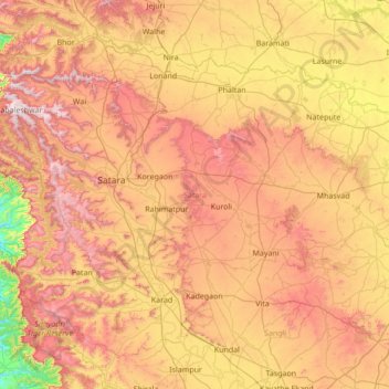
Nombre: Mapa topográfico Satara, altitud, relieve.
Lugar: Satara, Maharashtra, India (17.09116 73.53447 18.18243 74.90578)
Altitud media: 677 m
Altitud mínima: 46 m
Altitud máxima: 1.433 m
Haz una donación
Otros mapas topográficos
Haga clic en un mapa para ver su topografía, su altitud y su relieve.
Navi Mumbai
India > Maharashtra > Navi Mumbai
Navi Mumbai (Marathi pronunciation: , also known by its former name New Bombay), is a planned city off the west coast of the Indian state of Maharashtra in Konkan division. The city is divided into two parts, North Navi Mumbai and South Navi Mumbai, for the individual development of Panvel Mega City, which…
Altitud media: 30 m
Chakan
India > Maharashtra > Khed
Shiroli Chandus village, located 6 km north of Chakan, had been identified as the probable site for the proposed Pune International Airport, but due to the protests by the villagers & uneven topography, the site has been shifted to Purandar.
Altitud media: 624 m
Ichalkaranji
India > Maharashtra > Hatkanangle > Ichalkaranji
Ichalkaranji is located at 16°42′N 74°28′E / 16.7°N 74.47°E / 16.7; 74.47. It has an average elevation of 538 metres (1768 ft).
Altitud media: 562 m
Haz una donación
Alibag
India > Maharashtra > Alibag Taluka
Alibag is located about 120 km south of Mumbai, at 18°38′29″N 72°52′20″E / 18.64139°N 72.87222°E / 18.64139; 72.87222. The average elevation is 0 metres (0 feet).The District Government offices are located along the sea coast road. Alibag is the center place of Raigad District.
Altitud media: 12 m
Haz una donación
Haz una donación
Shrigonda
India > Maharashtra > Shrigonda
Shrigonda is a municipal council in Ahilyanagar - Ahmednagar district in the Indian state of Maharashtra. Shrigonda is located at 18°36′58″N 74°41′53″E / 18.616°N 74.698°E / 18.616; 74.698. It has an average elevation of 561 metres (1840 feet). As of the 2001 Indian census, Shrigonda had a…
Altitud media: 560 m
Parbhani
India > Maharashtra > Parbhani
Parbhani is located at 19°16′N 76°47′E / 19.27°N 76.78°E / 19.27; 76.78. It has an average elevation of 347 metres.
Altitud media: 411 m
Haz una donación
Sinnar
India > Maharashtra > Sinnar Taluka
Sinnar is located at 19°51′N 74°00′E / 19.85°N 74.0°E / 19.85; 74.0. It has an average elevation of 651.4 metres (2135 feet). Sinnar is one of the major industrial zones of Malegaon (MIDC) built around the city of Nashik which have multiple international production companies. It lies 30 km…
Altitud media: 684 m
Haz una donación
Satara
India > Maharashtra > Satara
Satara city has a tropical wet and dry climate (Köppen climate classification: Aw) that is influenced by the relatively high altitude and mountains surrounding the city. Summers are more hot than the winters. Satara city receives rainfall from 900 mm to 1,500 mm depending on the strength of the monsoon.
Altitud media: 748 m
Haz una donación
Haz una donación
Phaltan
India > Maharashtra > Phaltan
Phaltan has an average elevation of 568 meters (1,863 feet).
Altitud media: 561 m
Haz una donación
Jejuri
India > Maharashtra > Purandhar
Jejuri is located at 18°17′N 74°10′E / 18.28°N 74.17°E / 18.28; 74.17. It has an average elevation of 718 metres (2355 feet) mean sea level.
Altitud media: 728 m
Haz una donación
Haz una donación
Haz una donación
Haz una donación
Haz una donación
Haz una donación
Haz una donación
Kolhapur
India > Maharashtra > Karvir
Kolhapur is an inland city located in south-west Maharashtra state, 373 km (232 mi) south of Mumbai and 228 km (142 mi) south of Pune, 615 km (382 mi) north-west of Bengaluru, 530 km (330 mi) west of Hyderabad and 55 km (34 mi) west of Sangli. Within Maharashtra, Kolhapur's nearest cities and towns are…
Altitud media: 592 m
Ashta
India > Maharashtra > Walwa > Ashta
Ashta is a town and a municipal council in Sangli district in the state of Maharashtra, India. It is located at 16°57′N 74°24′E / 16.95°N 74.4°E / 16.95; 74.4. It has an average elevation of 567 metres (1860 ft). The name "Ashta" comes from the legend that Lord Shri Ram established eight…
Altitud media: 568 m
Haz una donación
Haz una donación
Haz una donación
Lonavala
India > Maharashtra > Mawal
Adjacent to the Lohagad fort lies the visapur fort which is part of the Lohagad-Visapur fortification. Visapur Fort is larger and at a higher elevation than its twin- Lohagad. It was built during 1713-1720 CE by Balaji Vishwanath.
Altitud media: 613 m
Haz una donación
Haz una donación
Haz una donación
Haz una donación
Haz una donación
Dombivli
India > Maharashtra > Kalyan Taluka > Kalyan-Dombivli
Dombivli is located at 19°13′06″N 73°05′12″E / 19.218433°N 73.086718°E / 19.218433; 73.086718. It has an average elevation of 13.534 meters (44.403 feet). The land here is rough and rocky by nature. The Ulhas river flows from its north. The Arabian sea is about 50 km west from Dombivli.
Altitud media: 11 m