
Mapa topográfico Bad Rodach
Mapa interactivo
Haga clic en el mapa para ver la altitud.
Acerca de este mapa
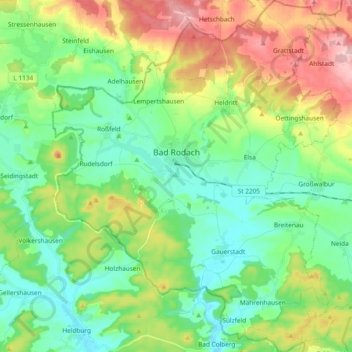
Nombre: Mapa topográfico Bad Rodach, altitud, relieve.
Lugar: Bad Rodach, Landkreis Coburg, Bayern, 96476, Deutschland (50.27308 10.71232 50.39271 10.86477)
Altitud media: 352 m
Altitud mínima: 284 m
Altitud máxima: 492 m
Otros mapas topográficos
Haga clic en un mapa para ver su topografía, su altitud y su relieve.
Untersiemau
Deutschland > Bayern > Landkreis Coburg
Untersiemau, Landkreis Coburg, Bayern, 96253, Deutschland
Altitud media: 319 m