
Haz una donación
Mapa topográfico Fairbanks
Haga clic en el mapa para ver la altitud.
Haz una donación
Fairbanks
Fairbanks is situated within the central Tanana Valley, characterized by a diverse and dynamic topography. The city straddles the Chena River, which flows southwest into the larger Tanana River, defining Fairbanks' southern border. To the north, a gradual incline leads into a chain of hills that ascend toward the White Mountains and the Yukon River. This elevation change is prominent, as some hills reach heights of approximately 3,000 feet (about 910 meters) above sea level. Meanwhile, the southern region is marked by the Tanana Flats, a broad expanse of marshes and bogs that extend for over 100 miles, eventually rising into the Alaska Range, often visible from Fairbanks on clear days. This region is intersected by numerous low streams and rivers, creating a rich network of waterways that contribute to the area's unique ecosystem.
Haz una donación
Acerca de este mapa
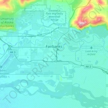
Nombre: Mapa topográfico Fairbanks, altitud, relieve.
Lugar: Fairbanks, Fairbanks North Star, Alaska, United States (64.77979 -147.81384 64.87821 -147.52442)
Altitud media: 146 m
Altitud mínima: 126 m
Altitud máxima: 334 m
Haz una donación
Otros mapas topográficos
Haga clic en un mapa para ver su topografía, su altitud y su relieve.
Haz una donación
Chatanika
United States > Alaska > Fairbanks North Star
Located 2 miles (3.2 km) east of the confluence of Cleary Creek and the Chatanika River, Chatanika lies 20 miles (32 km) northeast of Fairbanks. Its altitude is 896 feet (273 m).
Altitud media: 272 m