
Haz una donación
Mapa topográfico Chora
Haga clic en el mapa para ver la altitud.
Haz una donación
Chora
Chora is located in the southwestern part of Greece, in the peripheral unit of Messinia in Greece. It is 273 kilometers away from Athens, 205 kilometers away from Patras and 55 kilometers away from Kalamata. It has an altitude of 294 meters and it is built on the foothills of Aigaleo Mountain and 12 kilometers away from the Ionian Sea. Chora is 10 kilometers away from Gargalianoi and 21 kilometers away from Pylos. Romanos beach, Divari beach and the world-famous Voidokilia beach are located near the town.
Haz una donación
Acerca de este mapa
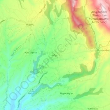
Nombre: Mapa topográfico Chora, altitud, relieve.
Altitud media: 324 m
Altitud mínima: 29 m
Altitud máxima: 853 m
Haz una donación
Otros mapas topográficos
Haga clic en un mapa para ver su topografía, su altitud y su relieve.
Proti
Greece > Peloponnese, Western Greece and the Ionian > Messenia Regional Unit > Gargalianoi Municipal Unit
Altitud media: 16 m
Palace of Nestor
Greece > Peloponnese, Western Greece and the Ionian > Messenia Regional Unit > Chora > Pisaski
Altitud media: 146 m
Municipality of Pylos and Nestor
Greece > Peloponnese, Western Greece and the Ionian > Messenia Regional Unit
Altitud media: 101 m