
Haz una donación
Mapa topográfico Limestone
Haga clic en el mapa para ver la altitud.
Haz una donación
Acerca de este mapa
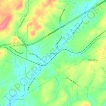
Nombre: Mapa topográfico Limestone, altitud, relieve.
Altitud media: 447 m
Altitud mínima: 413 m
Altitud máxima: 501 m
Haz una donación
Otros mapas topográficos
Haga clic en un mapa para ver su topografía, su altitud y su relieve.
Johnson City
United States > Tennessee > Washington County
Johnson City occupies a broad Appalachian valley in northeastern Tennessee, where the smoother urban floor around Sinking Creek and Brush Creek sits at roughly 1,600 feet (488 meters) above sea level and is framed by progressively higher, more rugged terrain. The landscape reflects the Ridge-and-Valley…
Altitud media: 513 m
Haz una donación
Johnson City
United States > Tennessee > Washington County
Johnson City occupies a broad Appalachian valley in northeastern Tennessee, where the smoother urban floor around Sinking Creek and Brush Creek sits at roughly 1,600 feet (488 meters) above sea level and is framed by progressively higher, more rugged terrain. The landscape reflects the Ridge-and-Valley…
Altitud media: 513 m