
Gracias por apoyar a este sitio ❤️
Haz una donación
Haz una donación
Mapa topográfico Letchworth
Haga clic en el mapa para ver la altitud.
Gracias por apoyar a este sitio ❤️
Haz una donación
Haz una donación
Acerca de este mapa
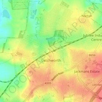
Nombre: Mapa topográfico Letchworth, altitud, relieve.
Lugar: Letchworth, Hertfordshire, England, United Kingdom (51.95965 -0.25510 51.99937 -0.19579)
Altitud media: 81 m
Altitud mínima: 47 m
Altitud máxima: 112 m
Gracias por apoyar a este sitio ❤️
Haz una donación
Haz una donación
Otros mapas topográficos
Haga clic en un mapa para ver su topografía, su altitud y su relieve.
Gracias por apoyar a este sitio ❤️
Haz una donación
Haz una donación
Gracias por apoyar a este sitio ❤️
Haz una donación
Haz una donación
Gracias por apoyar a este sitio ❤️
Haz una donación
Haz una donación
Gracias por apoyar a este sitio ❤️
Haz una donación
Haz una donación
Gracias por apoyar a este sitio ❤️
Haz una donación
Haz una donación
Gracias por apoyar a este sitio ❤️
Haz una donación
Haz una donación
Bishops Stortford Elsan Point
United Kingdom > England > Hertfordshire > East Hertfordshire
Altitud media: 78 m