
Mapa topográfico Chugchillan
Haga clic en el mapa para ver la altitud.
Acerca de este mapa
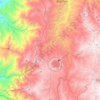
Nombre: Mapa topográfico Chugchillan, altitud, relieve.
Lugar: Chugchillan, Sigchos, Cotopaxi, Ecuador (-0.89499 -79.11735 -0.75441 -78.87170)
Altitud media: 3.158 m
Altitud mínima: 1.188 m
Altitud máxima: 4.280 m
Otros mapas topográficos
Haga clic en un mapa para ver su topografía, su altitud y su relieve.
Las Minas de la Plata
Ecuador > Cotopaxi > Sigchos > Palo Quemado > Las Minas de la Plata
Altitud media: 1.335 m