
Mapa topográfico Signal Hill
Haga clic en el mapa para ver la altitud.
Acerca de este mapa
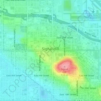
Nombre: Mapa topográfico Signal Hill, altitud, relieve.
Lugar: Signal Hill, Los Angeles County, California, United States (33.78979 -118.18493 33.81891 -118.14963)
Altitud media: 28 m
Altitud mínima: 3 m
Altitud máxima: 108 m
Otros mapas topográficos
Haga clic en un mapa para ver su topografía, su altitud y su relieve.
McCloud
United States > California > Siskiyou County
McCloud is located at 41°15′17″N 122°8′11″W / 41.25472°N 122.13639°W / 41.25472; -122.13639 (41.254682, -122.136321) on the southern slope of Mount Shasta, at an elevation of 3,271 feet (997 m) above sea level.
Altitud media: 1.010 m
Yosemite Valley
United States > California > Mariposa County > Yosemite Village > Yosemite Lodge
Altitud media: 1.479 m
Hemet
United States > California > Hemet
Dedicated to James Simpson, Hemet City Council 1947–48, and mayor 1950 to 1966. Simpson Park is a wilderness park located in the Santa Rosa Hills southeast of Hemet with sheltered picnic area and tables, barbecues, restrooms, and hiking trails. At an elevation of 2,500 feet (760 m), it provides an expansive…
Altitud media: 508 m
Yucca Valley
United States > California > San Bernardino County
Yucca Valley lies in the middle of the Morongo Basin at a base elevation of 3,300 feet. Joshua Tree National Park is adjacent to its southern border.
Altitud media: 1.106 m
Newbury Park
United States > California > Ventura County > Thousand Oaks
Newbury Park can be described as a town,[6] community,[94] or section[9] mostly within the Thousand Oaks city limits in addition to rural areas west of Thousand Oaks. Newbury Park is bordered by Lynn Road in the east and the Conejo Grade on the west. It borders the Santa Monica Mountains in the south, while…
Altitud media: 262 m
Twentynine Palms
United States > California > Twentynine Palms
According to the United States Census Bureau, the city has a total area of 59.1 square miles (153 km2), all land. The city is at an elevation of 1,988 feet (606 m). The Marine Corps Air Ground Combat Center Twentynine Palms is located there.
Altitud media: 690 m
Johannesburg
United States > California > Kern County
Johannesburg is a census-designated place (CDP) in Kern County, California, in a mining district of the Rand Mountains. Johannesburg is located 1 mile (1.6 km) east-northeast of Randsburg, at an elevation of 3,517 feet (1,072 m). The terminus of the Randsburg Railway was here from 1897 to 1933. The population…
Altitud media: 1.103 m
San Luis Obispo
United States > California > San Luis Obispo County > San Luis Obispo
Altitud media: 254 m
Wofford Heights
United States > California > Kern County
Wofford Heights is a census-designated place (CDP) in the southern Sierra Nevada, in Kern County, California, United States. Wofford Heights is located in the west Kern River Valley, 3.5 miles (5.6 km) south-southwest of Kernville, at an elevation of 2,684 feet (818 m). The population was 2,200 at the 2010…
Altitud media: 1.114 m
Bradley
United States > California > Monterey County
Bradley is an unincorporated community and census-designated place (CDP) in Monterey County, California, on the Salinas River 14 miles (23 km) south-southeast of San Ardo and 20 miles (32 km) north of Paso Robles. Bradley sits at an elevation of 548 feet (167 m). The population was 69 at the 2020 census, down…
Altitud media: 190 m
Susanville
United States > California > Lassen County
Susanville (formerly known as Rooptown) is a town in and is the county seat of Lassen County, California, United States. Susanville is located on the Susan River in the southern part of the county, at an elevation of 4,186 feet (1,276 m). Its population is 16,728 as of the 2020 census, down from 17,947 from…
Altitud media: 1.345 m
Morgan Hill
United States > California > Santa Clara County > Morgan Hill
Morgan Hill is approximately 39 km (24 mi) south of downtown San Jose, 21 km (13 mi) north of Gilroy, and 24 km (15 mi) inland from the Pacific coast. Lying in a roughly 6 km-wide (4-mi-wide) southern extension of the Santa Clara Valley, it is bounded by the Santa Cruz Mountains to the west and the Diablo…
Altitud media: 145 m
Quarry Lakes Regional Park
United States > California > Alameda County > Fremont > Eberly
Altitud media: 17 m
Independence
Independence is a census-designated place in Inyo County, California. Independence is located 41 miles (66 km) south-southeast of Bishop, at an elevation of 3930 feet (1198 m). It is the county seat of Inyo County, California. The population of this census-designated place was 669 at the 2010 census, up from…
Altitud media: 1.199 m
Rancho Santa Fe
The climate of Rancho Santa Fe is, for the most part, typical of the San Diego metropolitan area though its higher elevation and inland location lends itself to larger temperature variations.
Altitud media: 62 m
Thousand Oaks
United States > California > Ventura County > Thousand Oaks
The northern parts consist of mountainous terrain in the Simi Hills, Conejo Mountains and Mount Clef Ridge. Narrow canyons such as Hill Canyon cut through the steeper mountainous areas. Conejo Mountain and Conejo Grade are found in westernmost Newbury Park, while the southernmost parts of Thousand Oaks are…
Altitud media: 303 m
Santa Ana River Trail & Parkway
United States > California > San Bernardino County > San Bernardino
Altitud media: 310 m
Forbestown
United States > California > Butte County
Forbestown (formerly, Boles Dry Diggins and Forbes Diggins) is a census-designated place in Butte County, California. It lies at an elevation of 2772 feet (845 m). Its zip code is 95941 and its area code is 530. Forbestown had a population of 320 at the 2010 census.
Altitud media: 809 m
Menifee
United States > California > Riverside County
Menifee is a city in Riverside County, California, United States, and part of the Los Angeles Combined Statistical Area. The city is centrally located in Southern California in the Menifee Valley. It is almost 15 miles (24 km) north of Temecula and just north of Murrieta. Menifee is roughly 46 square miles…
Altitud media: 456 m
Gilroy
United States > California > Gilroy
Gilroy is located at 37°00′43″N 121°34′48″W / 37.012048°N 121.580080°W / 37.012048; -121.580080. It is approximately 26 km (16 mi) south of San Jose, California (Bailey Avenue (37.206770, -121.729150) to Monterey/Day Road (37.038210, -121.584480)) on U.S. Route 101 and 31 km (19 mi) inland…
Altitud media: 106 m
Wrightwood
United States > California > Wrightwood
Wrightwood is a census-designated place in San Bernardino County, California. It sits at an elevation of 5,935 feet (1,809 m). The population was 4,525 at the 2010 census, up from the population of 3,837 at the 2000 census. Wrightwood is located 77 miles northeast of Los Angeles.
Altitud media: 1.904 m
Mount Davidson
United States > California > San Francisco
Mount Davidson is the highest natural point in San Francisco, California, with an elevation of 928 feet (283 m). It is located near the geographical center of the city, south of Twin Peaks and Portola Drive and to the west of Diamond Heights and Glen Park. It dominates the southeastern view from most of…
Altitud media: 138 m
Fort Irwin
United States > California > San Bernardino County
Fort Irwin National Training Center (Fort Irwin NTC) is a major training area for the United States military in the Mojave Desert in northern San Bernardino County, California. Fort Irwin is at an average elevation of 2,454 feet (748 m). It is located 37 miles (60 km) northeast of Barstow, in the Calico…
Altitud media: 774 m
Mount Wilson Observatory
United States > California > Los Angeles County > Mount Wilson
Altitud media: 1.421 m
Lee Vining
United States > California > Mono County
Lee Vining (formerly Leevining, Poverty Flat, and Lakeview) is an unincorporated community and census-designated place (CDP) in Mono County, California, United States. It is located 25 miles (40 km) south-southeast of Bridgeport, at an elevation of 6,781 feet (2,067 m). Lee Vining is located on the southwest…
Altitud media: 2.180 m
King City
United States > California > Monterey County
King City (variants: Kings City, City of King) is a city in Monterey County, California, United States. It is located on the Salinas River 51 miles (82 km) southeast of Salinas, at an elevation of 335 feet (102 m). It lies along U.S. Route 101 in the Salinas Valley of California's Central Coast. King City is a…
Altitud media: 93 m
Oakdale
United States > California > Stanislaus County
Historically the area has been used for orchards and other agricultural uses. Some of the common soil types found in Oakdale are Delhi sand, Oakdale sandy loam, Hanford sandy loam, and Tujunga loamy sand. Oakdale is generally on level ground at an elevation of approximately 190 feet (58 m) above mean sea…
Altitud media: 52 m
Porterville
United States > California > Tulare County > Porterville
Porterville, lying along the foothills of the Sierras at an elevation of 455 feet (139 m), is located on State Highway 65, 165 miles (266 km) north of Los Angeles, and 171 miles (275 km) east of the Pacific Coast. The city has a strategic central location to major markets and a ready access to major…
Altitud media: 222 m
Gilroy
United States > California > Santa Clara County > Gilroy
Gilroy is approximately 16 miles (26 km) south of San Jose, California (Bailey Avenue (37.206770, -121.729150) to Monterey/Day Road (37.038210, -121.584480)) on U.S. Route 101 and 19 miles (31 km) inland from the Pacific Coast. Despite its apparent close proximity to San Jose, it is important to note that…
Altitud media: 218 m
Pinyon Pines
United States > California > Riverside County
It is located in a small valley between the San Jacinto Mountains and Santa Rosa Mountains, north of State Route 74. It takes its name from the Pinyon pine (Pinus monophylla) trees native to the area. Pinyon Pines sits at an elevation of approximately 4000 feet.
Altitud media: 1.276 m