
Haz una donación
Mapa topográfico Iskandar
Haga clic en el mapa para ver la altitud.
Haz una donación
Acerca de este mapa
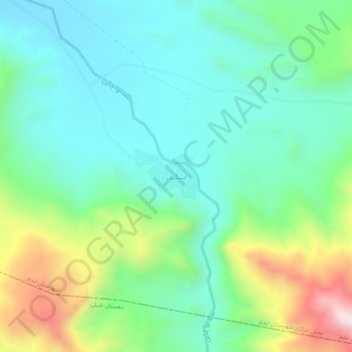
Nombre: Mapa topográfico Iskandar, altitud, relieve.
Altitud media: 1.806 m
Altitud mínima: 1.622 m
Altitud máxima: 2.278 m
Haz una donación
Otros mapas topográficos
Haga clic en un mapa para ver su topografía, su altitud y su relieve.
Tabriz
Iran > East Azerbaijan Province > Tabriz County
Tabriz (Persian: تبریز [tæbˈɾiːz] (listen); Azerbaijani: تبریز) is a city in northwestern Iran, serving as the capital of East Azerbaijan Province. It is the sixth-most-populous city in Iran. In the Quru River valley in Iran's historic Azerbaijan region between long ridges of volcanic cones in…
Altitud media: 1.538 m
Tabriz
Iran > East Azerbaijan Province > Tabriz County
Tabriz is in the Quru River valley in Iran's historic Azerbaijan region between long ridges of volcanic cones in the Sahand and Eynali mountains. Tabriz's elevation ranges between 1,350 and 1,600 m (4,430 and 5,250 ft) above sea level. The valley opens up into a plain that gently slopes down to the eastern…
Altitud media: 1.538 m
Haz una donación
Tabriz
Iran > East Azerbaijan Province > Tabriz County
Tabriz is in the Quru River valley in Iran's historic Azerbaijan region between long ridges of volcanic cones in the Sahand and Eynali mountains. Tabriz's elevation ranges between 1,350 and 1,600 m (4,430 and 5,250 ft) above sea level. The valley opens up into a plain that gently slopes down to the eastern…
Altitud media: 1.538 m
دهستان میدان چای
Iran > East Azerbaijan Province > Tabriz County > دهستان میدان چای
Altitud media: 2.075 m