
Mapa topográfico Green River
Mapa interactivo
Haga clic en el mapa para ver la altitud.
Acerca de este mapa
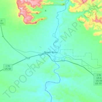
Nombre: Mapa topográfico Green River, altitud, relieve.
Lugar: Green River, Emery County, Utah, 84525, United States (38.94991 -110.30786 39.04646 -110.00398)
Altitud media: 1.349 m
Altitud mínima: 1.223 m
Altitud máxima: 2.048 m
Otros mapas topográficos
Haga clic en un mapa para ver su topografía, su altitud y su relieve.
Orangeville
United States > Utah > Emery County
Orangeville, Emery County, Utah, 84537, United States
Altitud media: 1.776 m
Castle Dale
United States > Utah > Emery County
Castle Dale, Emery County, Utah, 84513, United States
Altitud media: 1.758 m
Huntington
United States > Utah > Emery County > Huntington
Huntington, Emery County, Utah, 84528, United States
Altitud media: 1.767 m
Castle Dale
United States > Utah > Emery County > Castle Dale > Castle Dale
Castle Dale, Emery County, Utah, 84513, United States
Altitud media: 1.745 m
The Wickiup
United States > Utah > Emery County
The Wickiup, Emery County, Utah, United States
Altitud media: 1.979 m
Joes Valley Reservoir
United States > Utah > Emery County
Joes Valley Reservoir, Emery County, Utah, United States
Altitud media: 2.282 m
San Rafel Swell overlook
United States > Utah > Emery County
San Rafel Swell overlook, San Rafael River Road, Emery County, Utah, United States
Altitud media: 1.491 m