
Gracias por apoyar a este sitio ❤️
Haz una donación
Haz una donación
Mapa topográfico Mega
Haga clic en el mapa para ver la altitud.
Gracias por apoyar a este sitio ❤️
Haz una donación
Haz una donación
Mega
Mega is a town in southern Ethiopia. Located between Moyale and Yabelo on the paved highway south to Kenya, in the Borena Zone of the Oromia, this town has a latitude and longitude of 4°01′N 38°15′E / 4.017°N 38.250°E / 4.017; 38.250 with an elevation of 1740 meters above sea level. Named for a nearby mountain, this town is the administrative center of Dire woreda.
Gracias por apoyar a este sitio ❤️
Haz una donación
Haz una donación
Acerca de este mapa
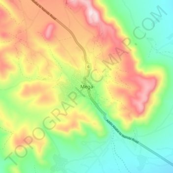
Nombre: Mapa topográfico Mega, altitud, relieve.
Lugar: Mega, Borena, Oromia Region, Ethiopia (4.01880 38.28089 4.09880 38.36089)
Altitud media: 1.746 m
Altitud mínima: 1.486 m
Altitud máxima: 2.098 m
Gracias por apoyar a este sitio ❤️
Haz una donación
Haz una donación