
Haz una donación
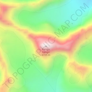
Mapa topográfico Kangju Kangri
Haga clic en el mapa para ver la altitud.
Haz una donación
Kangju Kangri
Kangju Kangri is a mountain in the Karakoram Range of Asia located in the union territory of Ladakh, India. With a summit elevation of 6,725 meters above sea level, it is the highest peak of the Pangong range, a subrange of the Karakoram. Kangju Kangri rises over the winding, tri-headed Kangju glacier and Pangong Lake to the east.
Haz una donación
Acerca de este mapa
Nombre: Mapa topográfico Kangju Kangri, altitud, relieve.
Lugar: Kangju Kangri, Leh Tehsil, Leh district, Ladakh, India (33.72521 78.52739 33.72531 78.52749)
Altitud media: 6.190 m
Altitud mínima: 5.820 m
Altitud máxima: 6.694 m
Haz una donación
Otros mapas topográficos
Haga clic en un mapa para ver su topografía, su altitud y su relieve.
Indus
India > Ladakh > Leh Tehsil
In the uppermost, highest part of the Indus River basin there are relatively few genera and species: Diptychus, Ptychobarbus, Schizopyge, Schizopygopsis and Schizothorax snowtrout, Triplophysa loaches, and the catfish Glyptosternon reticulatum. Going downstream these are soon joined by the golden mahseer Tor…
Altitud media: 4.192 m