
Haz una donación
Mapa topográfico Tianmen
Haga clic en el mapa para ver la altitud.
Haz una donación
Acerca de este mapa
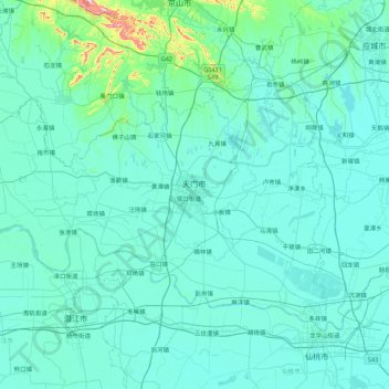
Nombre: Mapa topográfico Tianmen, altitud, relieve.
Lugar: Tianmen, Hubei, 431700, China (30.38018 112.58665 30.90630 113.46036)
Altitud media: 41 m
Altitud mínima: 16 m
Altitud máxima: 411 m
Haz una donación
Otros mapas topográficos
Haga clic en un mapa para ver su topografía, su altitud y su relieve.
Mount Wudang
China > Hubei > Danjiangkou City
Modern maps show the elevation of the highest of the peaks in the Wudang Shan "proper" as 1612 meters; however, the entire Wudangshan range has somewhat higher elevations elsewhere.
Altitud media: 1.172 m
Haz una donación
Mount Wudang
China > Hubei > Danjiangkou City
Modern maps show the elevation of the highest of the peaks in the Wudang Shan "proper" as 1612 meters; however, the entire Wudangshan range has somewhat higher elevations elsewhere.
Altitud media: 1.172 m
Haz una donación
Haz una donación
Mount Wudang
China > Hubei > Danjiangkou City
Modern maps show the elevation of the highest of the peaks in the Wudang Shan "proper" as 1612 meters; however, the entire Wudangshan range has somewhat higher elevations elsewhere.
Altitud media: 1.172 m
Haz una donación
Yuxi
Tempered by the low latitude and moderate elevation, Yuxi has a mild subtropical highland climate (Köppen Cwb), with short, mild, dry winters, and warm, rainy summers. Frost may occur in winter but the days still generally warm up to around 17 °C (63 °F). During summer, a majority of the days features some…
Altitud media: 66 m
Haz una donación
Haz una donación