
Haz una donación
Mapa topográfico Ashta
Haga clic en el mapa para ver la altitud.
Haz una donación
Ashta
Ashta is a city and a municipal council in Sangli district in the state of Maharashtra, India. It is located at 16°57′N 74°24′E / 16.95°N 74.4°E / 16.95; 74.4. It has an average elevation of 567 metres (1860 ft). The name "Ashta" comes from the legend that Lord Shri Ram established eight (Asht) Lord Mahadev temples in this area. The city is divided into 19 wards for which elections are held every 5 years. The Ashta Municipal Council has the population of 37,105 of which 19,171 are males while 17,934 are females as per the report released by Census India 2011.
Haz una donación
Acerca de este mapa
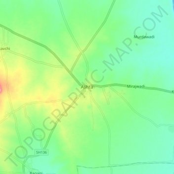
Nombre: Mapa topográfico Ashta, altitud, relieve.
Lugar: Ashta, Walwa, Sangli District, Maharashtra, 416300, India (16.90520 74.36710 16.98520 74.44710)
Altitud media: 568 m
Altitud mínima: 538 m
Altitud máxima: 631 m
Haz una donación
Otros mapas topográficos
Haga clic en un mapa para ver su topografía, su altitud y su relieve.