
Haz una donación
Mapa topográfico Greenville County
Haga clic en el mapa para ver la altitud.
Haz una donación
Acerca de este mapa
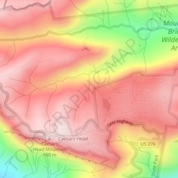
Nombre: Mapa topográfico Greenville County, altitud, relieve.
Altitud media: 819 m
Altitud mínima: 514 m
Altitud máxima: 975 m
Haz una donación
Otros mapas topográficos
Haga clic en un mapa para ver su topografía, su altitud y su relieve.
Lake Secession
United States > South Carolina > Abbeville County
Secession Lake is a reservoir on the Rocky River, a tributary of the Savannah River. The spillway elevation is 548 feet (167 m) above sea level. The reservoir extends north into Anderson County, but the CDP consists only of residences built around the lake within Abbeville County. The Antreville CDP borders…
Altitud media: 188 m
Murphys Estates
United States > South Carolina > Edgefield County > Murphys Estates
Altitud media: 160 m
Haz una donación
Haz una donación
Haz una donación
Haz una donación
Ridgeland
United States > South Carolina > Jasper County
Ridgeland is in northeastern Jasper County, with the center of town sitting on a low ridge at an elevation of 62 feet (19 m) above sea level. According to the United States Census Bureau, the town has a total area of 44.7 square miles (115.8 km2), of which 44.4 square miles (115.1 km2) are land and 0.3 square…
Altitud media: 15 m
Haz una donación
Haz una donación
Haz una donación
Haz una donación
Haz una donación
Haz una donación
Haz una donación
Lexington County
United States > South Carolina
According to the U.S. Census Bureau, the county has a total area of 757.62 square miles (1,962.2 km2), of which 699.00 square miles (1,810.4 km2) is land and 58.62 square miles (151.8 km2) (7.74%) is water. The largest body of water is Lake Murray, while other waterways include the Broad River, the Saluda…
Altitud media: 116 m
Haz una donación