
Haz una donación
Mapa topográfico Kazbegi
Haga clic en el mapa para ver la altitud.
Haz una donación
Kazbegi
Kazbek is located on the Khokh Range, a mountain range which runs north of the Greater Caucasus Range, and which is pierced by the gorges of the Ardon and the Terek. At its eastern foot runs the Georgian Military Road through the pass of Darial 2,378 meters (7,805 feet). The mountain itself lies along the edge of the Borjomi–Kazbegi Fault (which is a northern sub-ending of the North Anatolian Fault). The region is highly active tectonically, with numerous small earthquakes occurring at regular intervals. An active geothermal/hot spring system also surrounds the mountain. Kazbek is a potentially active volcano, built up of trachyte and sheathed with lava, and has the shape of a double cone, whose base lies at an altitude of 1,770 meters (5,800 feet). Kazbek is the highest of the volcanic cones of the Kazbegi volcanic group which also includes Mount Khabarjina (3,142 metres).
Haz una donación
Acerca de este mapa
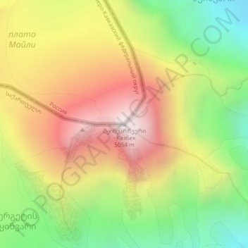
Nombre: Mapa topográfico Kazbegi, altitud, relieve.
Altitud media: 4.324 m
Altitud mínima: 3.634 m
Altitud máxima: 5.032 m
Haz una donación
Otros mapas topográficos
Haga clic en un mapa para ver su topografía, su altitud y su relieve.