
Mapa topográfico Loveland
Haga clic en el mapa para ver la altitud.
Acerca de este mapa
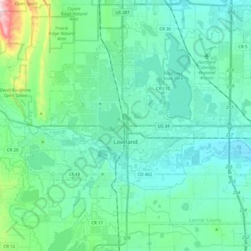
Nombre: Mapa topográfico Loveland, altitud, relieve.
Lugar: Loveland, Larimer County, Colorado, United States (40.34907 -105.15979 40.46587 -104.96208)
Altitud media: 1.547 m
Altitud mínima: 1.472 m
Altitud máxima: 1.926 m
Otros mapas topográficos
Haga clic en un mapa para ver su topografía, su altitud y su relieve.
Estes Park
United States > Colorado > Larimer County
Estes Park sits at an elevation of 7,522 feet (2,293 m) on the front range of the Rocky Mountains at the eastern entrance of the Rocky Mountain National Park. Its north, south and east extremities border the Roosevelt National Forest. Lumpy Ridge lies immediately north of Estes Park.
Altitud media: 2.543 m
Estes Park
United States > Colorado > Larimer County
Estes Park sits at an elevation of 7,522 feet (2,293 m) on the front range of the Rocky Mountains at the eastern entrance of the Rocky Mountain National Park. Its north, south and east extremities border the Roosevelt National Forest. Lumpy Ridge lies immediately north of Estes Park.
Altitud media: 2.420 m
Estes Park
United States > Colorado > Larimer County
Estes Park sits at an elevation of 7,522 feet (2,293 m) on the front range of the Rocky Mountains at the eastern entrance of the Rocky Mountain National Park. Its location is 40°22′22″N 105°31′09″W / 40.372856°N 105.519136°W / 40.372856; -105.519136. Its north, south and east extremities…
Altitud media: 2.543 m
Stanley Heights Subdivision
United States > Colorado > Larimer County > Estes Park
Altitud media: 2.345 m
Silver Lake
United States > Colorado > Larimer County > Loveland > Browns Corner
Altitud media: 1.524 m
Estes Park
United States > Colorado > Larimer County
Estes Park sits at an elevation of 7,522 feet (2,293 m) on the front range of the Rocky Mountains at the eastern entrance of the Rocky Mountain National Park. Its location is 40°22′22″N 105°31′09″W / 40.372856°N 105.519136°W / 40.372856; -105.519136. Its north, south and east extremities…
Altitud media: 2.409 m
La Poudre Pass
United States > Colorado > Larimer County
La Poudre Pass (elevation 10,184 ft (3,104 m)), a high mountain pass, is located in the Rocky Mountains of northern Colorado in the United States.
Altitud media: 3.218 m
La Poudre Pass
United States > Colorado > Larimer County
La Poudre Pass (elevation 10,184 ft (3,104 m)), a high mountain pass, is located in the Rocky Mountains of northern Colorado in the United States.
Altitud media: 3.218 m
Horseshoe Lake (South Dam)
United States > Colorado > Larimer County > Loveland
Altitud media: 1.515 m
Estes Park
United States > Colorado > Larimer County
Estes Park sits at an elevation of 7,658 feet (2,334 m) on the Front Range of the Rocky Mountains at the eastern entrance of the Rocky Mountain National Park. Its north, south and east extremities border the Roosevelt National Forest. Lumpy Ridge lies immediately north of Estes Park.
Altitud media: 2.543 m
Estes Park
United States > Colorado > Larimer County
Estes Park sits at an elevation of 7,522 feet (2,293 m) on the front range of the Rocky Mountains at the eastern entrance of the Rocky Mountain National Park. Its north, south and east extremities border the Roosevelt National Forest. Lumpy Ridge lies immediately north of Estes Park.
Altitud media: 2.429 m
Stanley Heights Subdivision
United States > Colorado > Larimer County > Estes Park
Altitud media: 2.345 m