
Haz una donación
Mapa topográfico Mairang
Haga clic en el mapa para ver la altitud.
Haz una donación
Acerca de este mapa
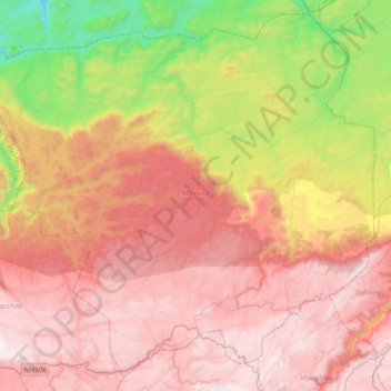
Nombre: Mapa topográfico Mairang, altitud, relieve.
Lugar: Mairang, Eastern West Khasi Hills, Meghalaya, 793120, India (25.51355 91.43921 25.82786 91.81415)
Altitud media: 1.135 m
Altitud mínima: 151 m
Altitud máxima: 1.918 m
Haz una donación
Otros mapas topográficos
Haga clic en un mapa para ver su topografía, su altitud y su relieve.
Haz una donación
Haz una donación
Jowai
India > Meghalaya > Thadlaskein
Jowai (IPA: ʤəʊˈwaɪ) is the headquarters of the West Jaintia Hills district of the state of Meghalaya, India, and is home to the Pnar, a sub-tribe of the Khasi people. It is located on a plateau surrounded on three sides by the Myntdu river bordering Bangladesh to the south (about 50 km from the…
Altitud media: 1.332 m
Haz una donación
Haz una donación
Cherrapunji (Sohra)
India > Meghalaya > Shella Bholaganj > Cherrapunji (Sohra)
It has an average elevation of 1,430 metres (4,690 ft) and sits on a plateau in the southern part of the Khasi Hills, facing the plains of Bangladesh. The plateau rises 660 meters above the surrounding valleys.
Altitud media: 1.248 m
Haz una donación