
Haz una donación
Mapa topográfico Merrimac
Haga clic en el mapa para ver la altitud.
Haz una donación
Acerca de este mapa
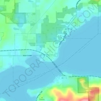
Nombre: Mapa topográfico Merrimac, altitud, relieve.
Lugar: Merrimac, Sauk County, Wisconsin, United States (43.36287 -89.65153 43.38659 -89.60362)
Altitud media: 250 m
Altitud mínima: 235 m
Altitud máxima: 332 m
Haz una donación
Otros mapas topográficos
Haga clic en un mapa para ver su topografía, su altitud y su relieve.
Spirit Lake
United States > Wisconsin > Sauk County
Devils Lake State Park offers 29 miles of hiking trails that vary based on difficulty level, length, and terrain. Among the 17 established trails, the most popular is the tumbled rocks trail. It sits at the edge of the lake on the west end, stretching a mile long. The trail is paved, allowing it to be…
Altitud media: 349 m
Natural Bridge State Park
United States > Wisconsin > Sauk County > North Freedom
Altitud media: 289 m
Haz una donación