
Gracias por apoyar a este sitio ❤️
Haz una donación
Haz una donación
Mapa topográfico Lecco
Haga clic en el mapa para ver la altitud.
Gracias por apoyar a este sitio ❤️
Haz una donación
Haz una donación
Lecco
The territory has a very variable altitude distribution: it ranges from 198 metres (650 ft) above sea level in the lake area to the maximum altitude of 1,875 metres (6,152 ft) above the sea level of Mount Resegone and this condition offers the city three different areas characterized by different morphologic and climatic characteristics.
Gracias por apoyar a este sitio ❤️
Haz una donación
Haz una donación
Acerca de este mapa
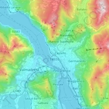
Nombre: Mapa topográfico Lecco, altitud, relieve.
Lugar: Lecco, Lombardy, 23900, Italy (45.81219 9.36677 45.90614 9.48490)
Altitud media: 575 m
Altitud mínima: 193 m
Altitud máxima: 1.647 m
Gracias por apoyar a este sitio ❤️
Haz una donación
Haz una donación
Otros mapas topográficos
Haga clic en un mapa para ver su topografía, su altitud y su relieve.