
Haz una donación
Mapa topográfico Belmont
Haga clic en el mapa para ver la altitud.
Haz una donación
Belmont
Belmont has been referred to as a "Mormon enclave" due to the location of the Boston Massachusetts Temple of the LDS Church at the highest elevation in the town. The prominent gold statue of the Angel Moroni atop the Temple was originally designed by Cyrus Dallin in nearby Arlington, Massachusetts.
Haz una donación
Acerca de este mapa
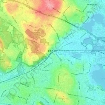
Nombre: Mapa topográfico Belmont, altitud, relieve.
Lugar: Belmont, Middlesex County, Massachusetts, United States (42.37506 -71.21195 42.41532 -71.15224)
Altitud media: 40 m
Altitud mínima: -1 m
Altitud máxima: 115 m
Haz una donación
Otros mapas topográficos
Haga clic en un mapa para ver su topografía, su altitud y su relieve.
Haz una donación
Haz una donación
Haz una donación
Haz una donación
Medford Hillside
United States > Massachusetts > Middlesex County > Medford > West Medford
Altitud media: 13 m
Hobbs Road
United States > Massachusetts > Middlesex County > Wayland > Cochituate
Altitud media: 66 m
Haz una donación
Haz una donación
Haz una donación
Haz una donación
Haz una donación
Haz una donación
Haz una donación
Haz una donación
Cambridge
United States > Massachusetts > Middlesex County > Cambridge
Cambridge obtains water from Hobbs Brook (in Lincoln and Waltham) and Stony Brook (Waltham and Weston), as well as an emergency connection to the Massachusetts Water Resources Authority. The city owns over 1,200 acres (486 ha) of land in other towns that includes these reservoirs and portions of their…
Altitud media: 31 m
Haz una donación
Haz una donación
Weston Station
United States > Massachusetts > Middlesex County > Weston > Weston Station
Altitud media: 55 m
Haz una donación