
Haz una donación
Mapa topográfico Caltanissetta
Haga clic en el mapa para ver la altitud.
Haz una donación
Caltanissetta
The expansive territory of Caltanissetta ranks as Italy's 14th largest comune by area and the fourth largest in Sicily, following Noto, Monreale, and Ragusa. Located in Sicily's interior, it has no coastline. The terrain, part of the Erean Mountains, is predominantly hilly, with its highest peak reaching 859 meters (2,818 feet) above sea level. The city center, at an elevation of 568 meters (1,864 feet), makes Caltanissetta the seventh-highest provincial capital in Italy, surpassed in Sicily only by Enna.
Haz una donación
Acerca de este mapa
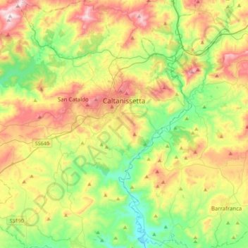
Nombre: Mapa topográfico Caltanissetta, altitud, relieve.
Lugar: Caltanissetta, Sicily, 93100, Italy (37.32953 13.86153 37.59852 14.15556)
Altitud media: 429 m
Altitud mínima: 160 m
Altitud máxima: 847 m
Haz una donación
Otros mapas topográficos
Haga clic en un mapa para ver su topografía, su altitud y su relieve.