Geolocalizar

Mapa topográfico Glenwood

Mapa interactivo

Haga clic en el mapa para ver la altitud.

Acerca de este mapa

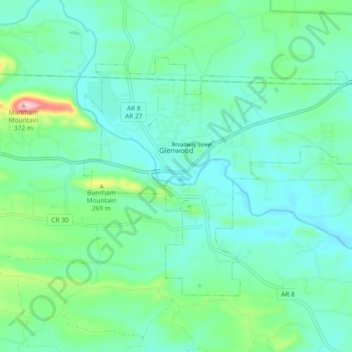
Nombre: Mapa topográfico Glenwood, altitud, relieve.

Lugar: Glenwood, Pike County, Arkansas, 71943, United States (34.29446 -93.57153 34.34642 -93.47869)

Altitud media: 193 m

Altitud mínima: 150 m

Altitud máxima: 358 m

Otros mapas topográficos

Haga clic en un mapa para ver su topografía, su altitud y su relieve.

Crater of Diamonds State Park

United States > Arkansas > Pike County > Murfreesboro > Kimberley

Crater of Diamonds State Park, Kimberley, Murfreesboro, Pike County, Arkansas, 71958, United States

Altitud media: 106 m

Little Missouri River

United States > Arkansas > Pike County

Little Missouri River, Pike County, Arkansas, 71958, United States

Altitud media: 159 m

Antoine

United States > Arkansas > Pike County

Antoine, Pike County, Arkansas, United States

Altitud media: 90 m

Delight

United States > Arkansas > Pike County > Delight

Delight, Pike County, Arkansas, 71940, United States

Altitud media: 119 m

Lake Greeson

United States > Arkansas > Pike County

Lake Greeson, Pike County, Arkansas, 71950, United States

Altitud media: 195 m

Murfreesboro

United States > Arkansas > Pike County

Murfreesboro, Pike County, Arkansas, 71958, United States

Altitud media: 114 m