
Haz una donación
Mapa topográfico Alsace
Haga clic en el mapa para ver la altitud.
Haz una donación
Alsace
Alsace has a semi-continental climate at low altitude and a continental climate at high altitude. There is fairly low precipitation because the Vosges protect it from the west. The city of Colmar has a sunny microclimate; it is the second driest city in France, with an annual precipitation of 600 mm, making it ideal for vin d'Alsace (Alsatian wine).
Haz una donación
Acerca de este mapa
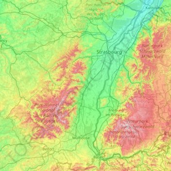
Nombre: Mapa topográfico Alsace, altitud, relieve.
Lugar: Alsace, Metropolitan France, France (47.42034 6.84132 49.07779 8.23285)
Altitud media: 414 m
Altitud mínima: 100 m
Altitud máxima: 1.471 m
Haz una donación
Otros mapas topográficos
Haga clic en un mapa para ver su topografía, su altitud y su relieve.
Paris
Paris in its early history had only the rivers Seine and Bièvre for water. From 1809, the Canal de l'Ourcq provided Paris with water from less-polluted rivers to the north-east of the capital. From 1857, the civil engineer Eugène Belgrand, under Napoleon III, oversaw the construction of a series of new…
Altitud media: 75 m
Haz una donación
Pont du Loup
France > Provence-Alpes-Côte d'Azur > Maritime Alps > Tourrettes-sur-Loup
Altitud media: 607 m
Haz una donación
Haz una donación
Haz una donación
Haz una donación
Haz una donación
Bayonne
France > New Aquitaine > Pyrénées-Atlantiques > Bayonne > Bayonne
In the late Quaternary, the current topographic physiognomy was formed—i.e. a set of hills overlooking a swampy lowland. The promontory of Bassussarry–Marracq ultimately extended to the Labourdin foothills. The Grand Bayonne hill is an example. Similarly, on the right bank of the Nive, the heights of…
Altitud media: 23 m
Serre Chevalier
France > Provence-Alpes-Côte d'Azur > Hautes-Alpes > Puy-Saint-André
The maximum elevation for skiing is at Telesiege Yret at 2,800 m (9,190 ft) above sea level, and the minimum is 1,200 m (3,940 ft), a total vertical drop of 1,600 m (5,250 ft). One of the outstanding features of Serre Chevalier is the wooded nature of the slopes. The timber line is at 2,150 m (7,050 ft),…
Altitud media: 2.256 m
Haz una donación
Haz una donación
Etang des Lames
France > Bourgogne – Franche-Comté > Yonne > Island > La Courcelle
Altitud media: 281 m
Mollard Durand
France > Auvergne-Rhône-Alpes > Savoy > Saint-Martin-de-la-Porte
Altitud media: 1.050 m
Haz una donación
Haz una donación
Haz una donación
La Gravette
France > Provence-Alpes-Côte d'Azur > Alpes-de-Haute-Provence > Barcelonnette
Altitud media: 1.282 m
Haz una donación
Haz una donación
Haz una donación
Haz una donación
Logis Du Fenestreau
France > Pays de la Loire > Vendée > Les Sables-d'Olonne > Les Soulardières
Altitud media: 31 m
Haz una donación
L'Égronnière
France > Pays de la Loire > Vendée > Montaigu-Vendée > Saint-Hilaire-de-Loulay
Altitud media: 42 m
Haz una donación
Haz una donación
Haz una donación
Haz una donación
Haz una donación
Col du Lautaret
France > Provence-Alpes-Côte d'Azur > Hautes-Alpes > Le Monêtier-les-Bains
From the west, the climb starts at Les Clapier, near Le Bourg-d'Oisans, from where the climb is 34.2 km (21.3 mi) long, gaining 1,312 m (4,304 ft) in altitude, at an average gradient of 3.8%, with the steepest section being at 7.5% in the first kilometre.
Altitud media: 2.261 m
Haz una donación
Haz una donación
Haz una donación
Haz una donación