
Mapa topográfico Mekong
Mapa interactivo
Haga clic en el mapa para ver la altitud.
Mekong
The elevation of the Tibetan Plateau during the Tertiary period was an important factor in the genesis of the south-west monsoon, which is the dominant climatic control influencing the hydrology of the Mekong Basin. Understanding the nature and timing of the elevation of Tibet (and the Central Highlands of Vietnam) therefore helps explain the provenance of sediment reaching the delta and the Tonle Sap Great Lake today. Studies of the provenance of sediments in the Mekong delta reveal a major switch in the source of sediments about eight million years ago (Ma). From 36 to 8 Ma the bulk (76%) of the sediments deposited in the delta came from erosion of the bedrock in the Three Rivers Area. From 8 Ma to the present, however, the contribution from the Three Rivers Area fell to 40%, while that from the Central Highlands rose from 11 to 51%. One of the most striking conclusions of provenance studies is the small contribution of sediment from the other parts of the Mekong basin, notably the Khorat Plateau, the uplands of northern Laos and northern Thailand, and the mountain ranges south of the Three Rivers area.
Acerca de este mapa
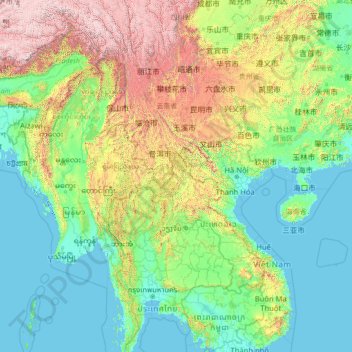
Nombre: Mapa topográfico Mekong, altitud, relieve.
Lugar: Mekong, Laos (10.27357 97.17769 31.13305 106.04407)
Altitud media: 795 m
Altitud mínima: -3 m
Altitud máxima: 6.545 m
Otros mapas topográficos
Haga clic en un mapa para ver su topografía, su altitud y su relieve.