
Gracias por apoyar a este sitio ❤️
Haz una donación
Haz una donación
Mapa topográfico Minatitlán
Haga clic en el mapa para ver la altitud.
Gracias por apoyar a este sitio ❤️
Haz una donación
Haz una donación
Acerca de este mapa
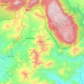
Nombre: Mapa topográfico Minatitlán, altitud, relieve.
Lugar: Minatitlán, Colima, Mexico (19.24577 -104.22743 19.49770 -103.88112)
Altitud media: 1.150 m
Altitud mínima: 298 m
Altitud máxima: 2.611 m
Gracias por apoyar a este sitio ❤️
Haz una donación
Haz una donación
Otros mapas topográficos
Haga clic en un mapa para ver su topografía, su altitud y su relieve.
Gracias por apoyar a este sitio ❤️
Haz una donación
Haz una donación
Colima City
Mexico > Colima > Municipio de Colima
Most of the municipality is located in the Valley of Colima. About half of the municipality has rugged, mountainous terrain, most of which is on the south and southeastern sides but with an average altitude of only 550 masl. These areas are part of the areas belonging to the Colima Volcano and a set of…
Altitud media: 649 m
Gracias por apoyar a este sitio ❤️
Haz una donación
Haz una donación