Mapa topográfico Nevado Salkantay
Mapa interactivo
Haga clic en el mapa para ver la altitud.
Acerca de este mapa
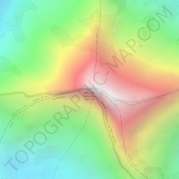
Nombre: Mapa topográfico Nevado Salkantay, altitud, relieve.
Lugar: Nevado Salkantay, Mollepata, Province of Anta, Cusco, Peru (-13.33284 -72.54722 -13.33274 -72.54712)
Altitud media: 5.266 m
Altitud mínima: 4.458 m
Altitud máxima: 6.238 m
Salcantay, Salkantay or Sallqantay (in Quechua) is the highest peak in the Vilcabamba mountain range, part of the Peruvian Andes. It is located in the Cusco Region, about 60 km (40 mi) west-northwest of the city of Cusco. It is the 38th-highest peak in the Andes and the twelfth-highest in Peru. However, as a range highpoint in deeply incised terrain, it is the second most topographically prominent peak in the country, after Huascarán.
Otros mapas topográficos
Haga clic en un mapa para ver su topografía, su altitud y su relieve.
Humantay Peak
Humantay Peak, Mollepata, Province of Anta, Cusco, 08645, Peru
Altitud media: 5.036 m