
Mapa topográfico County Down
Mapa interactivo
Haga clic en el mapa para ver la altitud.
Acerca de este mapa
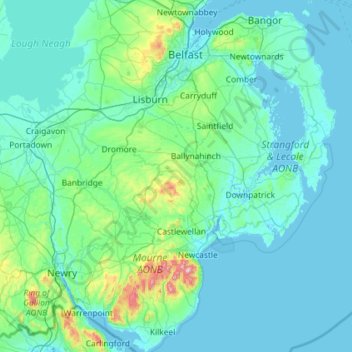
Nombre: Mapa topográfico County Down, altitud, relieve.
Lugar: County Down, Northern Ireland, United Kingdom (54.02289 -6.40037 54.69924 -5.42682)
Altitud media: 65 m
Altitud mínima: -3 m
Altitud máxima: 839 m
Otros mapas topográficos
Haga clic en un mapa para ver su topografía, su altitud y su relieve.
Derry/Londonderry
United Kingdom > Northern Ireland > County Londonderry
Derry is characterised by its distinctively hilly topography. The River Foyle forms a deep valley as it flows through the city, making Derry a place of very steep streets and sudden, startling views. The original walled city of Londonderry lies on a hill on the west bank of the River Foyle. In the past, the…
Altitud media: 88 m
Lagan Navigation (Abandoned)
United Kingdom > Northern Ireland > County Antrim > Belfast
Altitud media: 29 m
Magheramorne
United Kingdom > Northern Ireland > County Antrim > Craigstown Meadow
Altitud media: 32 m
Ederney
United Kingdom > Northern Ireland > County Fermanagh
By 1797, the settlement is recorded in the Topographia Hibernica as Ederny Bridge and "fair days" were held there.
Altitud media: 91 m
Loughgiel Millennium Centre
United Kingdom > Northern Ireland > County Antrim > Loughguile
Altitud media: 155 m
Castlecaufield
United Kingdom > Northern Ireland > County Tyrone > Castlecaulfield
Altitud media: 95 m